Provide leaders with information to develop a well-planned crowd-sourced data application that improves communication and speed response times in disasters. Recognize the potential benefits of crowd-sourced and employee-sourced real-time geospatial data during emergency response. Present steps taken by United States Department of Agriculture – Natural Resources Conservation Service (NRCS) Texas State Office for the deployment of the “dead cow tool” and share lessons learned. Provide a framework of questions and items that need to be addressed for the successful deployment of a real-time data collection tool.
What Did We Do?
In response to Hurricane Harvey in the fall of 2017, the Texas NRCS GIS staff developed on-line reporting tools to collect real-time data related to damages and animal mortalities that could be used by employees and the public. ESRI’s ArcGIS Collector Application was selected for its ease of use, ability to be used when off-line, and staff familiarity with the tool’s programming language. In this case, NRCS already had the necessary licensing for ArcGIS Online accounts.
The “dead cow tool” is a near real-time reporting tool for the public to identify locations, types and magnitude of agricultural losses. This provides NRCS and other agencies with data to request funding for emergency response and recovery funds to assist the local agricultural producers. However, significant concerns were raised relative to releasing the application for public use, so the data collection applications were then limited to a handful of NRCS employees within the disaster areas.
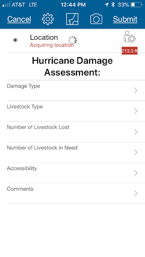
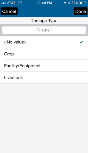
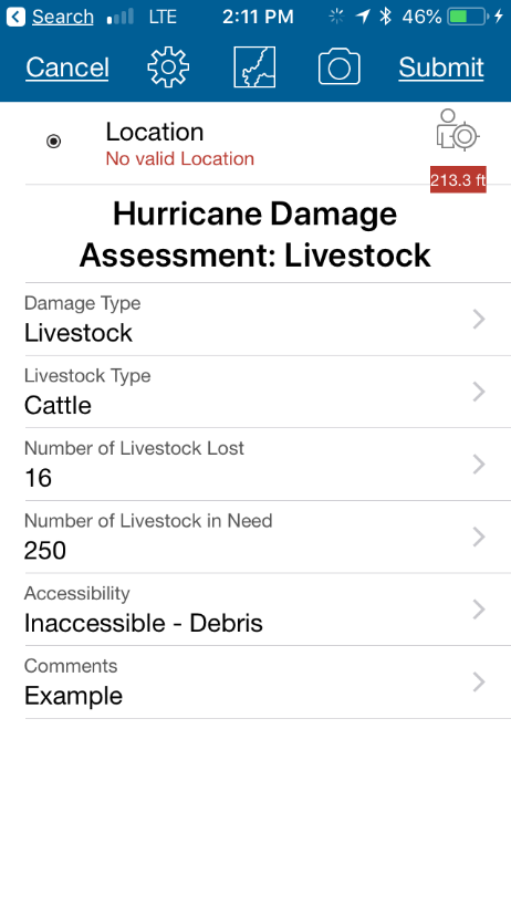
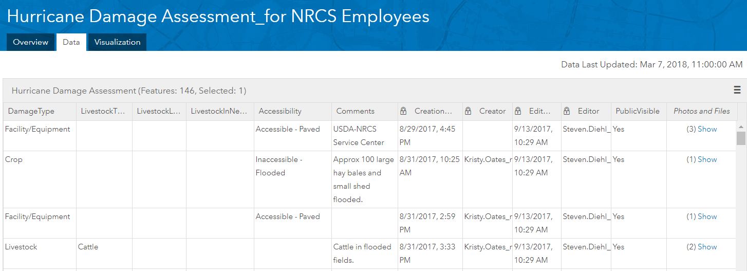
The Dead Cow Tool (displayed as Hurricane Harvey Data Collector Map) was designed to collect the following parameters: Damage Type; Livestock Type; Number of Livestock Lost; Number of Livestock in Need; Accessibility; and Comments. There was also an option to add or take images and add the location from a map previously downloaded onto a user’s mobile device (if network connectivity was lacking). Here are a few screenshots to serve as an example from an iPhone (Figures 1 – 6):
 |
 |
|
| Figure 1. Data collection maps developed in response to Hurricane Harvey | Figure 2. Main data collection screen for the “Dead Cow Tool” aka Hurricane Harvey Collector Map | |
 |
 |
|
| Figure 3. Options for damage types in the “dead cow tool” | Figure 4. Completed Livestock Damage Assessment ready to be submitted. There is includes the option to add a photo. | |
Texas NRCS developed and deployed another tool for employees to complete Damage Survey Reports while in the field. “In Hurricanes Ike and Rita, staff went out in the field, took handwritten notes about the damage, wrote down the location, took pictures and then had to return to the office, to download and enter the information on their computer. They had to look up the latitude and longitude points from their notes to document the exact location and then save all that information in several different locations. It was a long process for our staff,” says NRCS State Soil Scientist Alan Stahnke. “I knew there had to be a way to make it more efficient for them.” Stahnke had been working with Steven Diehl, GIS technician, and others on his staff for several months on an ArcGIS application, ArcCollector, based on ESRI map data. They had the basics down and when Hurricane Harvey showed up on the radar, they knew they had to work fast to get the application ready for staff in the wake of Harvey’s wrath. The resulting smart phone device field tool – the Hurricane Harvey Damage Reporter – is a method to record the damage and collect information on all the points into a central database. (Littlefield, 2017)
The Damage Survey Report tool reduced the time needed by field engineers by approximately 50% from the previous method. The data was available to others with access as it was entered – thereby providing timely data to managers and leadership. Additionally, it allowed the final reports to be developed by state office personnel further reducing the time required by the field – allowing them to take care of other pressing matters.

What Have We Learned?
Several lessons were learned: First, approve policies on data collection prior to the disaster – these need buy-in and flexibility. Second, decide how data will be released and identify typical reports. Third, develop Data Collection Applications in advance – allowing testing, training, familiarity, and formatting needed for user-friendliness. Fourth, select the correct Data Collection Tool. Fifth, identify data collection alternatives if the application cannot be realistically utilized – power outages, lack of network connection, closed roads, flooded areas, etc.
It is important to prepare, plan, and train prior to a disaster to allow time to adjust and/or develop policies and reduce knee-jerk reactions.
Data collection can have negative impacts if not properly administered and protected. Several identified concerns during Hurricane Harvey were protecting the data collected, preventing submittal of inappropriate language and/or photos, potential for someone submitting the data to believe that they had applied or requested assistance, and data distribution. Our NRCS GIS specialists (Texas and across the US) worked with ESRI developers to overcome some of the data protection and prevention of inappropriate material. However, obtaining clearance from leadership for public-use of the application was not obtainable in a timely matter.
Real-time data collection is a useful tool for both internal customers and the public when faced with a disaster and allows the timely coordination of resources for rapid response and recovery.
Disasters such as Hurricane Harvey require significant resources for response and recovery. Real-time data collection can aid in allocating resources. With animal mortalities, it is important that animals in sensitive environmental areas are properly disposed of in a timely manner. NRCS has provided technical and financial assistance for proper carcass disposal following natural disasters to reduce the associated environmental risk.
Generating Reports and Maps with Information Collected — Recognize the market impacts of sharing reported losses. NRCS must follow applicable federal rules and regulations to related to personally identifiable information. Generally, a report could be published with information grouped by county based on collected data provided there is more than one producer in the county with that type of livestock or commodity. For example, if there is only one farm in a county with emus, and the producer reported their losses of 50% of their emus, USDA Agencies could not share that data, as the producer could then be identified.
Policies are needed to address data collection with public interfaces. Consider modifications to existing policies or creating new policies to allow the use of crowd-source data.
The intent of the app and intended use of the data must be clearly conveyed to users. USDA Agencies raised concerns the public would believe that the tool indicated that they were applying for assistance, not simply reporting. (Stahnke, Jannise, & Northcut, 2018)
Prior to collecting data, appropriate policies should be written that address, how, when, where and why the information is needed and how it will be used in accordance with federal data collection requirements. The policies should be reviewed internally by a variety of users to ensure that the policy is clear and provides adequate accountability. Buy-in from all levels is needed prior to launching a data collection system to the public. Depending upon the type of organization that is collecting the data – a variety of controls may need to be established to protect the data.
- How the data will be collected and shared– this area should allow flexibility. Allowing public to enter data using their own devices may be necessary to obtain the data in a timely manner. What will public users gain by sharing their information?
- Will the data be shared with other agencies, non-governmental organizations (NGOs), etc.?
- If employees are allowed to use their own device, is there a possibility of a litigation hold on the personal device? (USDA – Forest Service, Mobile Geospatial Advisory Group, 2015)
- When does the data need to be collected? This may vary – for example, the number and type of livestock lost in a sensitive area may need to be reported as soon as the livestock are found; flooded fields and associated losses, road closures, or areas with downed power lines may have some lag-time in reporting over a period of several weeks as roads and properties become available for inspection
- Where does the data that has been submitted get collected?
- Who is going to oversee the data collection and create needed reports?
- Will the data be adequately protected? As mentioned, some of the data collected, particularly with potential images and audio embedded with file attributes, will likely include personal or sensitive data that must be protected.
- Why is the data being collected?
- Will it serve a purpose and be used?
- Can the data be potentially abused?
- What level of data integrity is required?
- Will certification or training be required for various users?
- Will additional weight be placed on data from “authenticated” or “certified” users?
- Who will be required to review of the proposed data collection system?
- Should these vary based on the scope of the project? Setting the review levels and identifying who is authorized for deployment of the tool in advance is helpful to know what rules need to be followed. Some flexibility should be provided to allow modifications and adaptations as needed during an emergency.
Selecting the appropriate data collection tool and platform is critical to success. There is an organization “Principles for Data Collection” that has created a guidance document for mobile data collection (MDC). Additionally, they host a “Digital Principles Forum — an online meeting place for peer learning, connection building, and debate on the Principles for Digital Development. Together with you, we aim to build a community that connects ICT4D, information technology, and international aid and humanitarian development practitioners with thoughtful curated content, relevant conversation and quality opportunities to improve their work.”
“How to Choose a Mobile Data Collection Platform” is a guidance document prepared by the Principal for Data Collection group. Below are some of the considerations that they have identified:
- Consider data and security needs including personal or sensitive data.
- Consider the ecosystem – following a disaster, internet and wireless connections may be intermittent or non-existent.
- Identify and prioritize selection criteria
- Short-term and long-term costs
- Number of users, surveys, and items
- Devices and data requirements for enumerators
- Security and privacy compliance
- Integration with other technology
- Offline collection
- Short Message Service (SMS) integration
- Unstructured Supplementary Service Data Integration
- Authentication and user roles
- Skip logic and data parameters
- Data analysis
- GIS and mapping
- Language
- Photos, audio and video
- Ease of setup and use
- Research MDC platform options
- Rank options
- Consider whether to customize an MDC platform
- Select and test your platform.
TIP: Be sure to test several devices in your context before making a final selection.
(Principles for Digital Development, 2018)
When developing and testing applications, consider the following:
- Users accessibility to AGOL, i.e., do they need a login in their company’s Enterprise ESRI platform or is the application in the public domain on AGOL.
- Amount of training required for user to input
- Ease of navigation and number of clicks required to complete form
- Varying size of screens on user devices (small screens vs. tablets)
- Test with a variety of different levels of users
- Types of reports and training required for the administrator
- Duration of the application and availability
Creating sample reports and identifying who can see specific data in advance will aid when a disaster does occur. In Texas, this type of data might be useful to the Texas Animal Health Commission, and other agencies involved in Emergency Support Function #11 – Agriculture and Natural Resources Annex (ESF-11).
The following items should be further investigated for disaster related activities:
- FEMA’s National Incident Management System
- How to share some information with users that have input data – allows them to know that their data is being utilized for a worthy cause
- Identifying other agencies that are working on recovery efforts with the same groups
- Setting up mechanisms to share data automatically rather than relying on an individual to send out reports
- Methodologies for ground-truthing and screening data quickly
Explore the possibilities of utilizing ESRI’s WorkForce application to track locations of employees for safety and workflow coordination.
It is important to consider that even with the best tools developed and ready for deployment – they might not be able to be used in the field if there is no power to charge the mobile data collection device or ability to transmit the data back to the database. Considerations of solar chargers for the mobile devices for employees might be helpful. Establishing alternate methods of communication such as, but not limited to, land lines, postal mail, drop off locations, leaving surveys at the gates, and 800 phone numbers should be implemented.
Future Plans
There are infinite possibilities for the collection and use of real-time data in a disaster. It is the opinion of the authors that the potential benefits greatly outweigh the risks of not obtaining and utilizing the data. We will continue to share the lessons learned to help others implement solid data collection tools.
Authors
Cherie LaFleur, P.E., Environmental Engineer, USDA – Natural Resources Conservation Service, Central National Technical Service Center, Fort Worth, Texas. Cherie.lafleur@usda.gov
Catherine Stanley, E.I.T., Water Quality Specialist, USDA – Natural Resources Conservation Service, Weatherford, Texas. Catherine.stanley@usda.gov
Additional Information
NRCS Develops New Web App to Expedite Agency Response to Harvey. .
Citations:
Collins, C. (2017, October 27). Retrieved from Texas Observer: https://www.texasobserver.org/agriculture-losses-estimated-200-million-harvey/
Fannin, B. (2017, October 27). Texas agricultural losses from Hurricane Harvey estimated at more than $200 million. Retrieved from AgriLife Today — Texas Agrilife Extension: https://today.agrilife.org/2017/10/27/texas-agricultural-losses-hurricane-harvey-estimated-200-million/
Littlefield, D. A. (2017, September). NRCS Develops New Web App to Expedite Agency Response to Harvey. Retrieved from USDA-NRCS: https://www.nrcs.usda.gov/wps/portal/nrcs/detail/tx/newsroom/stories/?cid=nrcseprd1351676
Principles for Digital Development. (2018, May 8). How to Choose a Mobile Data Collection Platform. Retrieved from Digital Principles: https://digitalprinciples.org/wp-content/uploads/PDD_HowTo_ChooseMDC-v3.pdf
Stahnke, A., Jannise, P., & Northcut, M. (2018, 05 15). USDA NRCS Texas Personnel. (C. Stanley, Interviewer)
The Weather Company. (2017, September 2). Historic Hurricane Harvey’s Recap. Retrieved from The Weather Company: https://weather.com/storms/hurricane/news/tropical-storm-harvey-forecast-texas-louisiana-arkansas
USDA – Forest Service, Mobile Geospatial Advisory Group. (2015, August). Internal Document: Collector for ArcGIS Field Data Collection Pilot for Enterprise GIS Using ArcGIS Online.
Acknowledgements
Alan Stahnke, State Soil Scientist, NRCS, Temple, TX.
Pam Jannise, State GIS Specialist, NRCS, Temple, TX.
Steven Diehl, Cartographic Technician, NRCS, Temple, TX.
Mark Northcut, Landscape and Planning Staff Leader, NRCS, Temple, TX.
The authors are solely responsible for the content of these proceedings. The technical information does not necessarily reflect the official position of the sponsoring agencies or institutions represented by planning committee members, and inclusion and distribution herein does not constitute an endorsement of views expressed by the same. Printed materials included herein are not refereed publications. Citations should appear as follows. EXAMPLE: Authors. 2019. Title of presentation. Waste to Worth. Minneapolis, MN. April 22-26, 2019. URL of this page. Accessed on: today’s date.