The Runoff Risk project was started in Wisconsin in 2011, with the realization at that time, there was no real-time runoff risk guidance available for manure applicators. The project has grown, with four states (Michigan, Minnesota, Ohio and Wisconsin) now operating real-time runoff risk forecast websites.
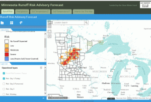
The Minnesota Runoff Risk Advisory Forecast (RRAF) system is a tool developed by the Minnesota Department of Agriculture (MDA) and the National Weather Service (NWS). It is designed to help farmers and commercial applicators determine the best time to apply manure to reduce the runoff risk of valuable nutrients and protect water resources. It is part of a regional risk advisory forecast project that utilizes existing NWS weather and watershed models in a water quality application. Figure 1 shows a screenshot of the website from July 1, 2018, indicating the runoff risk forecast in the central part of the state.
Runoff Risk Analysis
The NWS models continuously simulate soil moisture and temperature conditions as well as incorporating future precipitation and temperature forecasts and current and future snowpack. An algorithm that looks at chosen model state values is evaluated for a variety of risk conditions, such as runoff and soil saturation. Based on over 20 years of simulations, basin specific thresholds were created. Finally, there was post–processing of that data that is run on the output to produce risk events. This information is provided daily to the project partners through data servers. The data is processed and the website is updated twice daily. The graphic displays the different risk events predicting the likelihood of today (Day 1), tomorrow (Day 2), and Day 3 or multi-day (Day 1 through Day 3 combined) runoff events. Farmers and commercial applicators use an interactive map to locate their field and find their forecasted risk. Users can also sign up for email or text messages for their county that alert them to a severe runoff risk for that day.
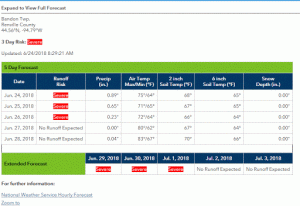
Runoff risk is grouped into four categories: No event, Low, Moderate and Severe. When the risk is Moderate or Severe, it is recommended that the applicator evaluate the situation to determine if there are other locations or later dates when the application could take place. Figure 2 shows results for a specific location in Bandon Township in Renville County, Minnesota. For the first three days, the risk of runoff at that specific location was Severe, which indicated that a producer should wait to apply.
Daily Mapping Information

The RRAF website also provides statewide forecasted daily average two inch soil depth temperatures which can be useful at planting time, daily average six inch soil depth temperatures which are helpful when determining fall fertilizer application in appropriate areas and daily precipitation forecasts. Figure 3 shows the daily soil temperature forecast at the six inch depth for the state of Minnesota. The colored dots are real time soil temperature gauges that can be interactively clicked on to reveal current soil temperature. The color of the dot is not reflective of the temperature at the gauge. It simply notes what entity is in charge of the gauge.
Potential of RRAF
This is a relatively new application that has been implemented in Minnesota since March 2018. The potential impacts of usage on this could be quite large. Any time movement of manure to water resources can be minimized is a success for the farmer and the environment. The overall goal of the presentation is to make people aware of this tool, share information on the performance, and encourage potential users to add this tool to their “toolbox”. The main message is to check conditions, delay if necessary, and spread on the day when there is least potential impact to the environment.
Further partnerships are desired to continue to get the word out on this application. Yearly multi-state coordination meetings occur, with the next meeting coming up in Ohio in August 2019. Version 3 of the RRAF will be derived from the National Weather Service National Water Model. Development on this version will start in Spring 2019 and should take four years for it to be merged into the National Water Model system. For MDA, we continue to promote RRAF website and monitor the output, comparing it to real time data to make sure that the model is working correctly.
Heather Johnson, Hydrologist 3, Minnesota Department of Agriculture
Heather.johnson@state.mn.us
Additional information
-
- Minnesota Runoff Risk Advisory Forecast: www.mda.state.mn.us/rraf
- Michigan EnivroImpact: https://enviroimpact.iwr.msu.edu/
- Ohio Nutrient Applicator Forecast: https://agri.ohio.gov/wps/portal/gov/oda/divisions/plant-health/resources/ohio-applicator-forecast#:~:text=The%20Ohio%20Applicator%20Forecast%20is,risk%20for%20applying%20is%20low.&text=Moderate%20and%20Severe%20risks%20appear,through%20or%20above%20the%20ground.
- Wisconsin Runoff Risk Advisory Forecast: http://www.manureadvisorysystem.wi.gov/runoffrisk/index
The authors are solely responsible for the content of these proceedings. The technical information does not necessarily reflect the official position of the sponsoring agencies or institutions represented by planning committee members, and inclusion and distribution herein does not constitute an endorsement of views expressed by the same. Printed materials included herein are not refereed publications. Citations should appear as follows. EXAMPLE: Authors. 2019. Title of presentation. Waste to Worth. Minneapolis, MN. April 22-26, 2019. URL of this page. Accessed on: today’s date.